


A Brief Description and History of The West Coast Trail
Nestled along the southwest shoreline of Vancouver Island lies the world famous West Coast backpacking trail. The West Coast Trail, part of Pacific Rim National Park, attracts over 5000 trekkers each year. This 75km trail offers experienced backpackers access to the islands canopied rainforests, sandy beaches, beautiful vistas and centuries of history and tradition. Some claim that trekking the West Coast Trail is the hike of a lifetime and they might just be right.
History of The West Coast Trail
The origins of the WCT are unlike anything of its kind. The trail is built along a treacherous section of the Pacific Ocean known as the Graveyard of The Pacific. This rugged coastline has claimed numerous ships along the trail and has taken countless lives.
The most notable shipwreck occurred in January of 1906. The passenger steamer Valencia out of Vancouver sank claiming 125 lives (some sources cite more) of the 160 passengers and crew aboard.
After this disaster the Canadian Government, under pressure from the public, started to implement efforts to prevent such accidents and to bolster rescue efforts. Two of the initiatives were the building of the Pachena Bay Lighthouse and a more thorough build out of the existing trail network along the coastline. This trail would come to be called the Dominion Lifesaving Trail and would help with the extraction and rescue of shipwreck survivors.
As maritime technology began improving there was a steady decline in nautical disasters and the trail’s use for lifesaving purposes decreased. The last noted shipwreck in the area was in 1948.
In 1973 the Dominion Lifesaving Trail became part of the Pacific Rim National Park. The name was later changed to The West Coast Trail and is now predominantly used for recreational purposes.
The Local Landscape
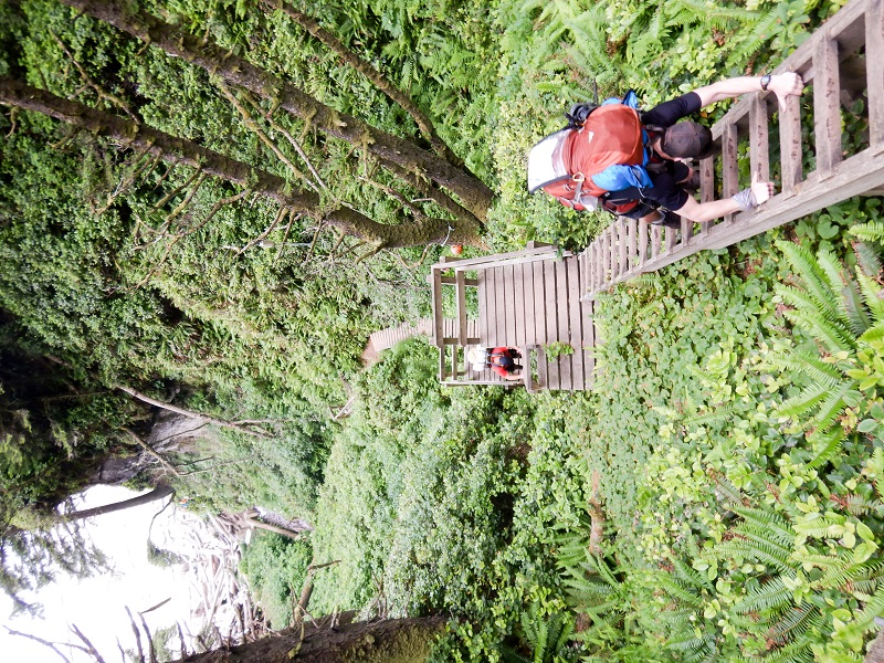
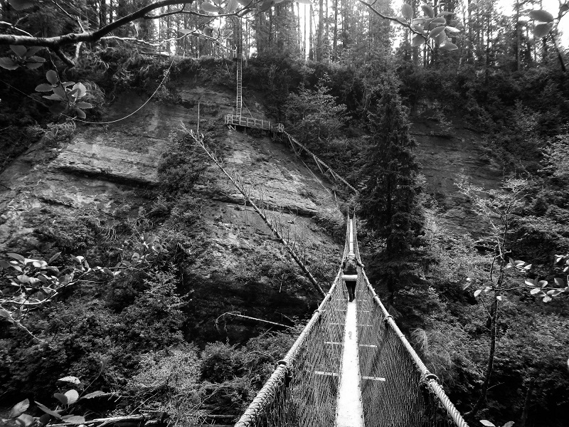
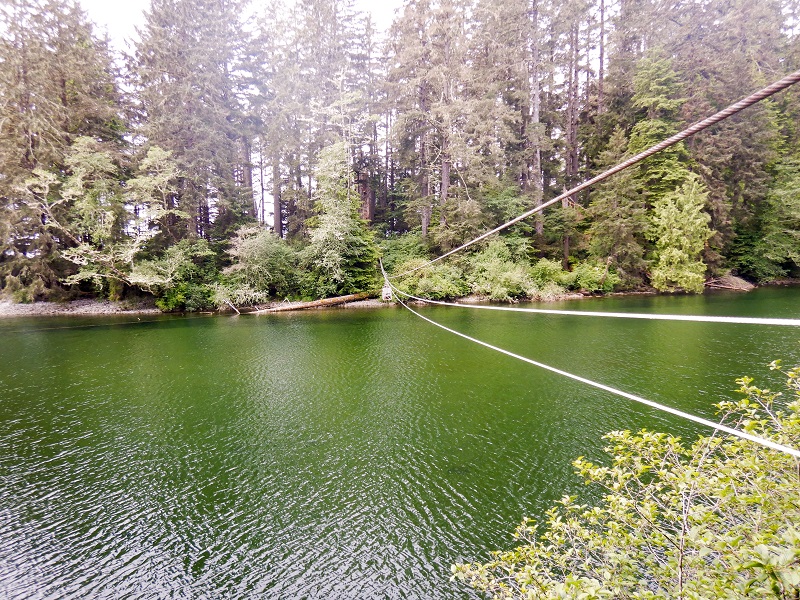
The WCT runs from Bamfield (Pachena Bay) to Port Renfrew (Gordon River). The trail can be traversed in either direction and offers a mix of hiking terrain including the island’s temperate rainforest interior and sandy ocean beaches. In order to accommodate the challenging terrain, Parks Canada has built an incredible infrastructure to help hikers. Within the 75km trail there are over 130 bridges of various lengths and designs, more than 30 sets of ladders with some reaching over 200 feet, 5 cable cars at various river crossing, kilometers of boardwalks in various states of repair and 2 ferry crossings. No two kilometers on the West Coast Trail are the same.
Trekking along the inland trail hikers can expect protection from the sun but also more humid hiking conditions. The terrain will offer some magnificent vistas of the Pacific Ocean but hikers will have to work a little harder for these views. Many areas have prolonged sections of mud, roots, downed trees and other obstacles. Trekking through these areas will be slower because of this and the frequent elevation changes are more physically demanding.
The beach sections offer hikers a change of pace and an opportunity to make up some time. Tide pools on the beach and rock shelfs offer a lot of interesting sea life for curious hikers. Knowledge of local tides is very important as there are several sections of the beach that can only be accessed when tides are below certain levels. All hikers are provided with tide charts during the mandatory Parks Canada orientation/registration process. Terrain on the rock shelfs after the tide is out can be slippery so hikers should be cautious. There are also a number of surge channels that should be avoided at all cost. Even at low tide, getting stuck in there channels can be disastrous.
Several areas of The West Coast Trail travel through protected lands; specifically Treaty Settlement Lands and Reserves. This area of the island is home to the Huu-ay-aht, Ditidaht and Pacheedaht First Nations. Signage for these areas is clearly posted and hikers are asked to respect these areas and camping is expressly prohibited.
How To Get On The Trail
Permits can be arrange between May 1st and September 30th. Pre-booking permits for the trail is required. In year’s past Parks Canada offered standby access to the trail however this was eliminated in 2018. Space is limited and there are only 70 permits issued each day (25 from Pachena Bay, 25 from Gordon River and 20 from Nitinat Village). Permits are made available to reserve (usually) in early January so keep an eye on the Parks Canada website for details.
Once you have secured your permits getting to the trailhead and back will be your next challenge. Both trailheads are remote and transportation is required at both ends. Thankfully there are a couple of services that shuttle hikers from Victoria, Nanaimo and other locations on Vancouver Island. We used the West Coast Trail Express (www.trailbus.com) and had a great experience. We highly recommend this service.
Once you’ve arrived at your starting destination there is one last task to complete. There is a mandatory orientation for all hikers that must be completed before you can access the WCT. This orientation takes place daily at 10am and 2pm and lasts approximately 30 minutes. It is 30 minutes well spent. You will learn a little bit of the trails history but most importantly the “dos and don’ts” of hiking the WCT.
With your orientation behind you, you’re now ready for the hike of your life!
Trail Highlights
(All distance markers on the trail count up for hikers heading southbound and count down for northbound hikers. The below list is in order for southbound hikers.)
Sea Lion Haul Out Rock (8km): Around the 8km mark there is a small trail that winds down towards the ocean. Here curious hikers will find a lookout with a great view of some local sea lions as they sun themselves and playing.
Pachena Lighthouse (9km): This 20m high lighthouse was first lit in 1908. It is pristinely maintained and still in operation today.
Michigan Boiler (12km): One of the most prominent remnants of the many shipwrecks along the West Coast Trail. This is located right along the beach and you can’t miss it.
Valencia Bluff (18km): Valencia Bluff overlooks the site of the tragic SS Valencia shipwreck of 1906. Hikers are treated to some creature comforts as there are 2 Muskoka chairs located at the lookout.
Klanawa Cable Car (23km): The first cable car (for southbound hikers) which also happens to be the longest cable car. It might be a little nerve-racking at first but it sure beats swimming.
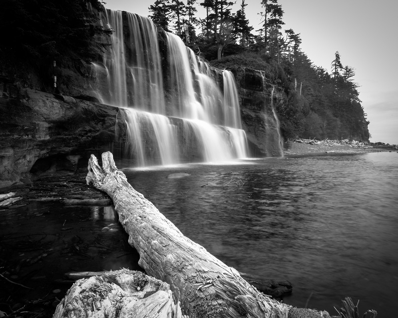
Tsusiat Falls (25km): One of the gems along the WCT. This is the most picturesque of all the waterfalls. Consider taking a dip and washing off the dust from the trail.
Nitnat Narrows Ferry and Crab Shack (33km): The first ferry and your first signs of civilizations in the last few days. Located on the south side of the river is a crab shack. Hot food (fresh fish etc.), cold drinks and if you ask nicely they may even have some beer. Bring your wallet, it’s not cheap but it’s well worth every penny.
Carmanah Lighthouse (44km): This is the second operating lighthouse along the WCT. Established before the Pachena Bay Lighthouse in 1891 it offers more spectacular views of the coastline.
Chez Monique’s (45km): It is easy to walk past and think nothing of it, but this tented and tarped structure offers hikers more warm food and cold drinks. Try the 8oz prime rib burger and don’t forget to add bacon and cheese. There is also a small concession with chips, chocolates bars and a wide variety of beer and other alcoholic offerings. It’s rumoured that 2018 will be the last operating season for this family run business; let’s hope that’s just a rumour.
Carmanah Creek Cable Car (46km): This cable car offers a shorter trip than the Klanawa car and can even be skipped if the water levels in the creek are low enough.
Walbran Creek Cable Car (53km): This cable car can be skipped if you hit the tides along the beach access correctly. If you’re camping at Walbran and want some fun in the evening why not give it a rip if you skipped it earlier.
Logan Creek Ladders and Suspension Bridge (56km): This is one of the largest ladder sets on the WCT. Thankfully hikers will have gained lots of experience on WCT ladders by this point in the trip. Enjoy the view from the middle of the suspension bridge but try not to look down while navigating the slightly off camber ladders!
Cullite Creek Ladders and Cable Car (58km): Massive ladders work their way down to the river crossing cable car and hikers are greeted with an equally impressive set of ladders going back up. We guarantee that you’ll feel the burn.
Camper Bay Cable Car (62km): This small cable car almost seems like an imposition but it’s better than having wet feet; especially if you’re just starting your day from the Camper Bay campground.
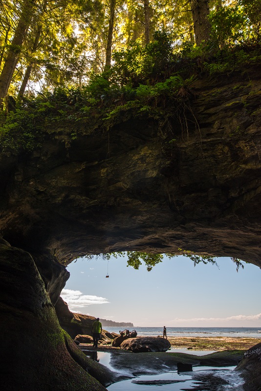
Owen’s Point (67km): Quite possibly the most unique area on the WCT. The Point can only be hit at tides below 1.8m so it takes some timing and planning. This natural (open) cave system allows hikers to explore an area of the trail that is usually underwater.
Thrasher Cove Ladders (70km): Here we have another massive set of ladders to greet our hikers. Southbound travelers will start their final day on the trail with a leg workout and northbound hikers will have to tackle them before settling in for the night.
Derelict Donkey Engine (72km): This relict from the by-gone logging days on the West Coast is an impressive machine. It is easy to appreciate how hard the logging operations would have been back 100 years ago when you see this piece of machinery.
Gordon River Ferry (75km): For southbound hikers this bitter sweet ferry crossing marks the end of your journey. Remember to pull the marker (located at the bottom of the last ladder) up into the air to signal for the ferry to come. Northbound hikers are lucky as they have this fun little ferry ride and 75kms of adventure before them.
Further Reading
Planning for any trip can be daunting and tedious and a West Coast Trail trip is no different. There are a few places for information and some great resources available out there. We would suggest the following:
- The Parks Canada website contains a lot of great up to date information about the West Coast Trail. You will need to book your permits through Parks Canada so it is wish to familiarize yourself with the site anyway. They also offer up a great WCT Preparation guide, relatively recent maps of the trial and a video series that will help set some expectations and get your trip planning started. All of these resources can be found at: https://www.pc.gc.ca/en/pn-np/bc/pacificrim/activ/activ6a
- Blisters and Bliss is a 3rd party guidebook penned by David Foster and Wayne Aitken. This book has been around since the 1980s (don’t worry it’s been updated; they are on their 9th edition) and offers up great tips for hiking the WCT. The styling’s of our authors is rather humourous and there are dozens of whimsical illustrations to chuckle over. With a price point less than $20 we would highly recommend this purchase to help plan your trip. We would also recommend bringing this along for the hike; it makes a great field reference. Find it HERE
- Hiking on the Edge by Ian Hill offers a more serious and robust look at The West Coast Trail. This book dives into the history of the area and offers beautiful, full colour photos of the area. It is a good companion piece to Blisters and Bliss which was a slightly better resource for planning a WCT hike. This can be purchased HERE

Leave a comment