
**Article Originally Posted April 18th, 2016**

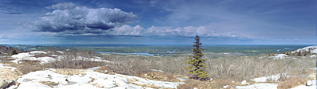
It’s hard to visit Killarney Provincial Park and not fall in love with the white quartz mountains and crisp blue lakes. This impressive ecosystem makes Killarney a unique place to visit in Ontario. Those who visit immediately realize why Killarney is often referred to as the “Crown Jewel” of Ontario’s Parks.
Beyond the picturesque façade of Killarney lies one of Ontario’s most rugged and challenging hiking trails, The La Cloche Silhouette Trail.
The Name
The La Cloche Silhouette Trail was named after Franklin Carmichael’s 1939 painting of the same name. Carmichael was an active member of the famous Canadian Group of Seven painters and artists. His love for the Killarney, along with the support from several other famous Canadian artists, was a leading factor in the formation of Killarney Provincial Park in 1964. Many of Killarney’s lakes, trails and landmarks bear the names of famous Canadian artists that were connected to the area.
Trail Features
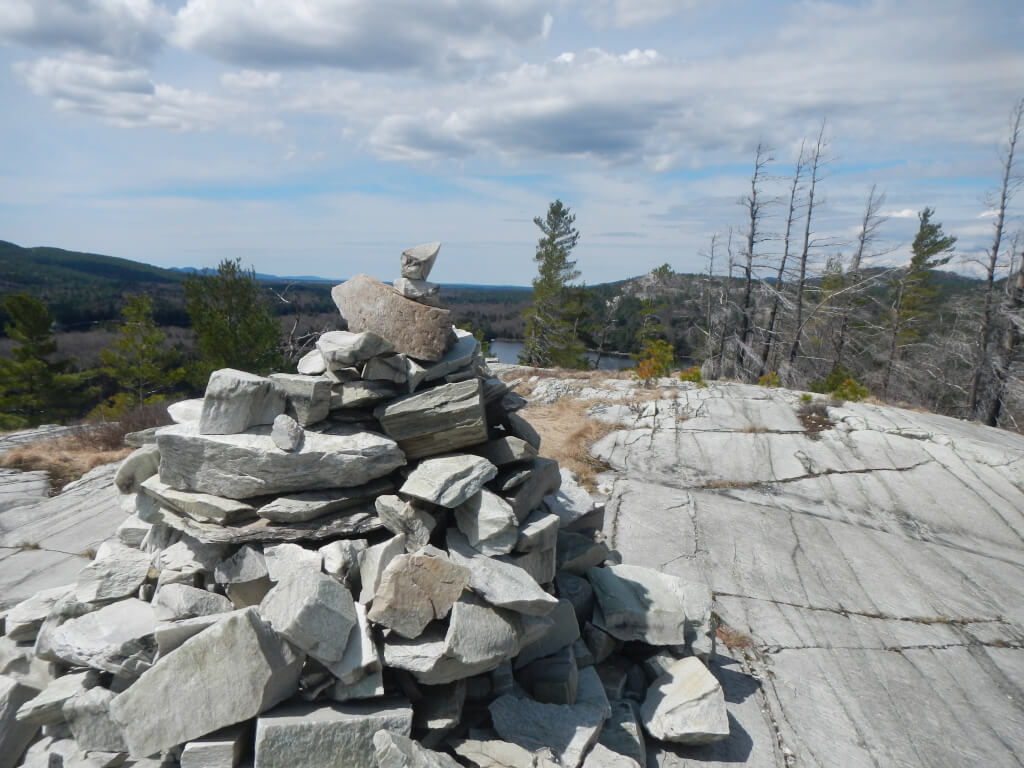
Tackling the La Cloche Silhouette trail is not for the novice hiker or for the faint of heart. This trail offers hikers some of the most spectacular vistas within the park, but achieving these views is easier said than done. At a total distance of 78km (48miles) and a total elevation gain of 2620m (8595 feet), the La Cloche trail requires hikers to be physically fit and to have a strong knowledge of trip planning, backpacking and backcountry experience. Attempting the trail without these essentials is not advised. The trail is well marked with blue arrows and rock cairns however a map and compass are recommended.
The Trail
The trail head is located at the George Lake Campground just off of Highway 637. Permits can be purchased at the Park Office. If you are attempting to complete the trail in less than the recommended time (7 days), be prepared to be labelled as “High Risk”. You must register for specific campsites along the way and booking in advance, especially during July and August, is highly recommended. There are 34 sites scattered along the trail however the distances between sites could be several kilometers; factor this in while planning.
The loop can be completed clockwise or counter clockwise. It is often said that starting off clockwise makes for an easier trip as the terrain is less aggressive early on when your hiking packs are the heaviest.
Trail Sections
The first section of trail (travelling clockwise) is the Baie Fine section. This 14km trail rolls through hardwood forests and offers many nice views of some of the park’s smaller lakes. While the terrain is fairly easy, don’t get too cocky! At the end of this section, hikers will have the pleasure of tackling Killarney’s most famous portage, The Pig.
The Baie Fine section gives way to the Threenarrows portion of the trail. At 19km, this section of trail takes the hikers along the shorelines of Threenarrows Lake. Hikers will notice that the terrain begins to become more challenging and the tree makeup in the areas is predominantly cedar trees found in the low lying wetlands. At this point of the trip the trail becomes much more isolated as you move away from the more easily accessed areas.
The third and most recent section of trail to be developed is the Hansen section. Completed in 1987, the Hansen trail, named after famed Canadian Rick Hansen, connected the Threenarrows and Silver Peak portions to complete the La Cloche Silhouette Trail. At a modest distance of 15km, the Hansen section of the trail is the most challenging along the loop. This is also the most isolated section of trail and the furthest from ‘civilization’. Take special care to move cautiously as there are areas of near vertical ascent and descent.
A trip to Killarney is not complete without a trek to the top of the park’s highest point, Silver Peak. This fourth section stretches 16km and allows backpackers, hikers and day trippers a chance to climb to the top of Silver Peak. The challenging and steep ascent takes about an hour and rewards you with the best vista in the park. On clear days Georgian Bay and the town of Sudbury can be seen. Don’t be surprised to run into others on this section of trail as it is very popular with canoeists who visit Silver Peak as a day trip. The Silver Peak side trail up the mountain will add another 4km to your overall trip.
The fifth and final portion of the La Cloche trail is the Killarney Ridge. At 10km, this is the shortest section of the trail, but it offers the most dynamic range of terrain. The most popular point of interest on this section is The Crack, a large rock and boulder scattered crevasse that needs to be traversed to continue on. The Crack is another hotspot for day hikers and canoeists alike.
Completing the Killarney Ridge portion of the trail returns hikers to the east side of George Lake and concludes a 78km loop of the La Cloche Silhouette Trail.

100km Rumour
Shortly after the completion of the Hansen section of the trail that connected two previous out and back trails into a loop, a Killarney Park Assistant Superintendent was asked what the total length of the trail was. He generously estimated the trail length to be 100km. For some strange reason and nearly 30 years later, this guessed distance is still incorrectly associated with the trail. The actual trail length, with a visit to Silver Peak is 78km.
Trying It For Yourself
If you are interested in exploring the La Cloche Silhouette trail but don’t know where to start (beyond this article) there are some resources available to you. I would recommend the Friends of Killarney Park website as a starting point (http://www.friendsofkillarneypark.com/). For a small price you can purchase the La Cloche Silhouette Trail Guide from their site (https://www.friendsofkillarneyparkstore.com/La-Cloche-Silhouette-Trail-Guide-p/20.htm). This book written by Melissa McCulloch is an essential resource for planning a trip. If you wish to ‘dip your toe in the water’ another option is to do shorter out and back trips along the Baie Fine and Killarney Ridge sections of the trail. The Killarney Ridge and Silver Peak areas will provide a good example of the terrain of the trail.
Jeff’s Maps also has a very detailed map available for free that provides excellent information and tips on the trail. http://www.thekillarneymap.com/
There will be a follow up article to this that outlines our trip planning efforts as Mark Highfield and I prepare for an early spring trek along the La Cloche Silhouette Trail.
