

Algonquin Provincial Park in Ontario offers a wide variety of activities and for all types of people. One of the more popular draws to the area are the hiking trails. The Park offers interior/backcountry hiking for the more seasoned outdoor enthusiasts and for the more reserved adventurers, a vast number of day hikes and interpretive trails that are easily accessed off of Highway 60.
Now that everyone is up to speed with the ins and outs of backpacking (read: A Beginner’s Guide To Backpacking), you will need someplace to hike.
Let’s just focus on the backpacking trails that Algonquin offers and we will worry about the day hiking trails later.
The Highlands:
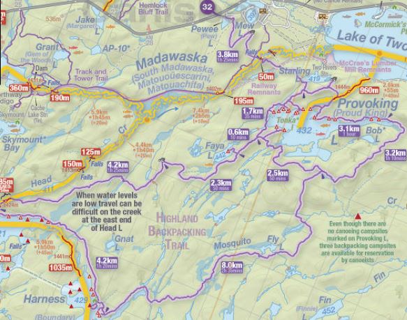
The Highland backpacking trail offers a great introduction to hiking in Algonquin Park. The trail is easily accessed off of Hwy 60 at kilometer marker 29. The highlands offer 2 loops; the short loop at 18km and the longer loop at 35km.
Permits are picked up at the Mew Lake Campground. If you are travelling during peak seasons it is recommend that you book in advance.
The short loop winds its way through beautiful Algonquin forests and offers up a nice outlook of Mew Lake. The trail is in excellent shape and offers only modest elevation changes. The route circles Provoking Lake with the majority of campsites available on the north side of the lake. This route can be completed in 2 days, however with the lack of campsites on the south side of the lake, it will likely mean breaking the trip into a 6km day and a 12km day. To avoid this, plan for a 2 night, 3 day trip.
The longer loop starts at the trail head and travels southwest to Head Lake, followed by a stop at Harness Lake. From here, the trail climbs back up to the east side of Provoking Lake where hikers join up with the short loop.
At 35km the longer loop is more aggressive and you will need to put a 13km day before reaching the campsites on Head Lake. As with the short loop, the campsite distribution requires hikers to plan ahead to avoid longer hiking days. Most hikers will want to take 3 nights, 4 days to complete this loop.
Tips For Hiking The Highlands:
- Plan your campsites strategically so that your hiking days are within your abilities.
- Take advantage of the lookouts, even if this means a small side detour.
- The Head Creek is a great area for local Algonquin moose. Keep your camera ready.
- There are often long stretches of hiking without water access to filter drinking water. Carry at least 2 liters of water with you and fill up whenever you have the opportunity.
For more details about The Highlands, see our video that highlights Faya Lake on the Highlands Trail.
Eastern Pines:
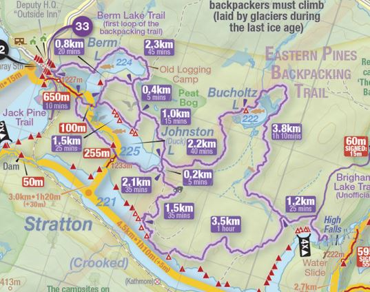
The Eastern Pines backpacking trail is accessed through the east side of the park. Accessing the park from this side can be a bit of a chore, but it is worth the investment in time. Permits are picked up at the Achray Campground office. To avoid a long car ride and arriving to find all the sites book, prearrange your sites.
There are a maze of trails in the Eastern Pines but the common routes will take hikers to Stratton Lake, High Falls (a must visit) or Johnston Lake. Distances for hikes range from 6km loops all the way up to 22km for the longest loop. 1 night or 2 night trips are reasonable in this area but with the long drive to the trailhead, you may wish to stay 3 or 4 nights.
With relatively easy terrain and only modest elevation changes, the Eastern Pines offer great introductory backpacking. Be warned that the shallow root structures of the pine forests make tripping and foot injuries a possibility so please hike with care.
Tips For Hiking The Eastern Pines:
- Make sure you save time to visit High Falls. This unique structure offers a series of swimming pools and a natural rock slide. Fun for the whole family.
- Calculate your travel time to Achray Lake and then your campsites accordingly to avoid getting caught in the dark. Travel to Achray can take several hours (6 hours from Toronto)
- The loop that travels around Bucholtz Lake is cluttered with large boulders left from receding glaciers. It offers a very unique hiking experience.
- Make certain that you stop off at the Barron Canyon day hiking trail that you pass along the way to Achray Lake. This short 1.5km trail should not be missed.
Western Uplands:

The Western Uplands offers the penultimate Algonquin overnight backpacking experience. The trail offers 2 separate access points; one off of Hwy 60 (AP 31) and the other on the west side of the park (AP 4). The Uplands offers 3 loops that measure in at 33km, 56km and 88km respectively.
While the trail is easy to access from the west side of the park I would not recommend tackling these trails until you have good backpacking experience. The terrain resembles that of The Highland Trails, but the distances make for more challenging hikes and require more detailed planning. Once you have travelled through The Highlands and the Eastern Pines though, set your sights on these beautiful trails.
Tips For Hiking The Western Uplands:
- Make sure you stop at either Maple Leaf or Maggie Lake, they are spectacular.
- Ramona Lake has challenging water access but worst of all lots of frogs. Don’t expect to get any sleep on this lake.
- Make certain you seek out up to date trail conditions before setting out. The last few years have seen high waters with sections of the trail washed out and difficult to navigate.
Now that you have a taste for the backpacking trails that Algonquin Park has to offer, I would recommend investigating the La Cloche Silhouette Trail in Killarney Provincial Park.
**Special thanks to Jeff’s Maps for the use of their wonder map for this article.**

Leave a comment