

Canadians love talking about hockey, politics and the weather. There’s more than enough political talk right now, and the ponds haven’t frozen, so I figured, let’s look at weather. I’ve always had a fascination with mother nature and always wanted to learn more about clouds and weather systems so I can be better prepared for the days ahead. Here’s some helpful info I’ve picked up along the way (rain can also mean snow, I just didn’t want to type rain/snow). Also, I am far from a meteorologist, if you have any tips, or see a correction needed, please let me know!
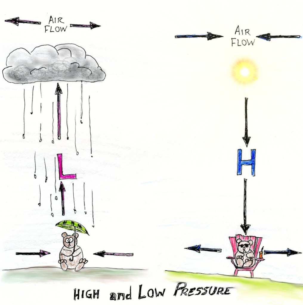
High and Low pressure
We often think of clouds as moving across the sky (which they do) but rarely do we think of their up’s and down’s. As air flow rises it cools, which can cause condensation and formation of water droplets (or ice), which form clouds and precipitation; rain or snow. Air flow that drops is “drying”.
High pressure is sinking air, and low pressure is rising air. For reasons beyond my understanding, air flows away from a high pressure system, and towards a low pressure system.
As seen in the the cross-cut diagram wth our bear friends, low pressure means rain, high pressure means no rain. It is the weather we’re speaking here, so that rule isn’t in pen.
What is a cold or warm front?
A front is the area where two different air masses meet, warm and cold. In a cold front, the warm air rises quickly, which leads to fast heavy rain and thunderstorms, then clearing skis. In a warm front, the warm air rises slower, leading to those gloomy clouds and extended periods of rain. After a warm front passes, fair weather can move in, followed by a cool front.
Clouds
There are many types and sub-types, I won’t get into all of them, but there are some really cool ones not listed here (fallstreak, lenticularis, nacreous, roll and shelf clouds, wall clouds…) that are worth checking out.
Clouds below 2000metres:
Stratus clouds-This is the gray low, fog like blanket cloud that is responsible for the light drizzle that keeps us in the tent in the morning. They normally burn off by noon.
Stratocumulus- Like Stratus clouds, can produce steady rains if they’re all lumped together. AS long as they stay apart, you’re gold.
Cumulus– These are the fun, fluffy poof clouds we all see shapes in. If they are spread out on blue skis, it’ll be a nice day. If they are growing vertically, they mean heavy showers.
Clouds between 2000m and 7000m:
Altocumulus- These clouds indicate good weather ahead
Altostratus-These are the gray days. Not raining yet, but the sun is barely visible thru them. If they darken, rain is coming.
Clouds above 7000m:
Cirrocumulus (mackerel Sky)-These are the high flying “fish scale” type clouds that can look like ripples of water on a pond, they’re a good sign.
Cirrostratus– these clouds can form “sun Dogs”, ice crystals cause the halo effect. If Cirrus clouds start to form sun dogs, it’s a sign of rain.
Cirrus- These look like a horse’s mane high in the sky, and normally stand out in the blue sky. They can foreshadow rain in a day or two as they come just ahead of a warm front.
And clouds that start below 2000m and tower above 7000m:
Cumulonimbus– (aka Thunderheads, anvil tops): these can really damper a trip and are the most dangerous of all cloud formations, producing hail, lightning, strong winds, heavy rain and tornados. Jerks.
Those are the basics. High’s, Low’s, cold and warm fronts all help to produce different clouds and weather patterns. There’s a lot more to it but hopefully the above information will help on a trip. Oh, and if the cows are lying down, it’s going to rain. Always bring a tarp, playing cards, and raingear.

For more info:
http://oceanservice.noaa.gov/education/yos/resource/JetStream/index.htm
https://weather.gc.ca/canada_e.html
Cloud chart:By Valentin de Bruyn / Coton (Own work) [CC BY-SA 3.0 (http://creativecommons.org/licenses/by-sa/3.0) or GFDL (http://www.gnu.org/copyleft/fdl.html)], via Wikimedia Commons

I’m learnding!
LikeLike